Can I download map data either in a KML or GeoJSON file for use with Google Earth or ArcGIS?
As discussed in this FAQ you can map your client data using the Neoserra mapping feature. Additionally, you can also download a KML map for use with Google Earth and/or a GeoJSON map for use with ESRI ArcGIS. In this FAQ we will discuss:
- Can I download a KML/GeoJSON file?
- Can I create a KML application feed?
- Why would I want to map my client data in either Google Earth or ArcGIS?
- Can I export the coordinates?
Can I download a KML/GeoJSON file?
Yes! Assuming that you have report permissions to the client data in your database.
First, create your filter to identify the clients that you want to map. Once you have created your filter, select Reports|Map to get a visual representation of your clients. To download the KML or GeoJSON file click on the floppy disk in the upper right corner of the interface:
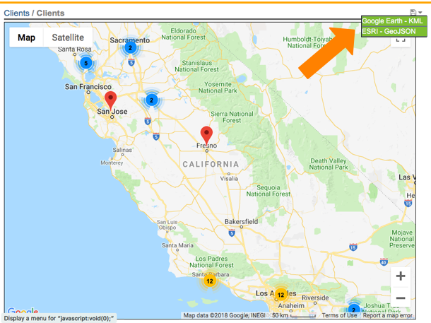
Select the file format that you want to download, based upon the third-party application that you will be using (KML for Google Earth and other products that support KML; or GeoJSON for ESRI ArcGIS and other products that support GeoJSON). The download file will include a list of coordinates that can be imported into the third-party application.
Can I create a KML application feed?
Maybe. Only Neoserra administrators can create KML applicaton feeds.
Again, you will first need to create a filter to identify the clients to be included. In order to create an application, you will need to save your filter. Once the filter has been saved, go to your account Preferences and scroll to the very bottom of your Preferences:
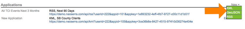
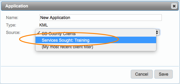
Select New|KML or New|GeoJSON depending upon which third party application you intend to use (KML for Google Earth and other products that support KML; or GeoJSON for ESRI ArcGIS and other products that support GeoJSON), and then select your saved filter as the source for the dataa:
Click "Save" and you will now have you application link. The benefit of the application link over the download file, is that the application link is always current based upon the clients in your database. In other words, if you create the filter on day 1 and you use the associated application again 90 days later, any then new clients that now meet the filter parameters will automatically be included. You can click on the link to open up the data in either Google Earth or ArcGIS respectively.
Why would I want to map my client data in either Google Earth or ArcGIS?
Because you may want to overlay your clients' locations with natural disaster maps; or with census bureau maps; or HUBZone maps (although these are hard to find); or minimum wage maps; or any other economic development type map. For example:
- FEMA maps: https://gis.fema.gov/DataFeeds.htm
- Oregon Flood maps: http://www.oregonriskmap.com/index.php?option=com_content&view=article&id=21:clackamas-county&catid=11&Itemid=12
- California Minimum Wage maps: https://www.arcgis.com/home/webmap/viewer.html?webmap=b113d07b7eb246ac8b8754e2ad67d82c
- Galesburg, IL HUBZone map: https://www.arcgis.com/home/webmap/viewer.html?useExisting=1&layers=57d78dbcadc84d85be106214e7bb34cf
Google Earth is a free application that can be downloaded from https://www.google.com/earth/download/gep/agree.html. Google Earth is a third-party application that is not supported by OutreachSystems. While we believe that Google Earth can be a beneficial tool when mapping client data, it should be noted that any customer support assistance for this application should be directed to Google, not OutreachSystems.
Once you have Google Earth installed you can link in your Neoserra client data and any other map by going to Add|Network Link.
Can I export the coordinates?
Yes! Assuming that you have report permissions to the client data in your database.
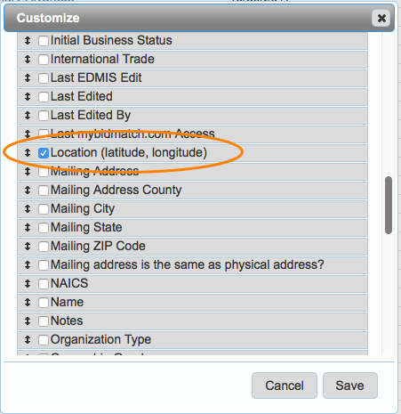
Rather than downloading a KML file or a GeoJSON file you can also export the latitudinal and longitudinal coordinates to a CSV file. The coordinates will appear in one column as a string. Again, you will first want to create a filter, to identify the clients whose coordinates you want to export. With the selected clients listed on the screen, click Filter|Select Columns and choose the fields that you want to include in your view:
Click Save, and your screen will include all the fields that you will export. Now, click Reports|Quick Report and choose the CSV (Export) format:
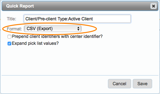
Keep in mind that the coordinates will be exported in ONE column (not two) as a string: latitude, longitude (eg. "34.4,-119.7?).
Want more? Browse our extensive list of Neoserra FAQs.