How to display my clients on a visual map using geocoding?
You can use the Neoserra mapping feature to display your clients on a visual map so that you can see the general distribution of clients within your service area.
We hope that this feature will be able to assist you when:
- You go to visit a client and what to know what other clients might be along the way that you can stop in on.
- You are planning a training event and you are looking for a location with the largest concentration of clients in the area.
- You have a congresswoman visiting the local coffee shop and she wants to know if there are any clients in the immediate area that she might be able to visit.
- You want to know where the majority of your woman-owned businesses are located.
There are many different reasons why you might want to map your clients and see their distribution across your service area.
Generally speaking you will not want to map all of your clients and pre-clients on a map. The process of mapping your clients is usually coupled with a filter. For example, you may only want to map your active clients in which case you will want to create a filter of active clients. Alternatively, you may want to map your clients with 5 or more employees, in which case you will first need to create the filter before you can map the clients. Using a filter, you decide what group of clients you want to map.
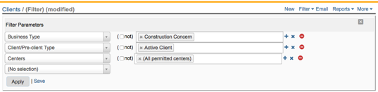
Here is a sample filter to help us map all of our construction companies in our Neoserra database:
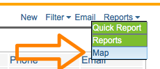
Once the results have been presented on the screen, you can now select the mapping option found under the Reports menu:
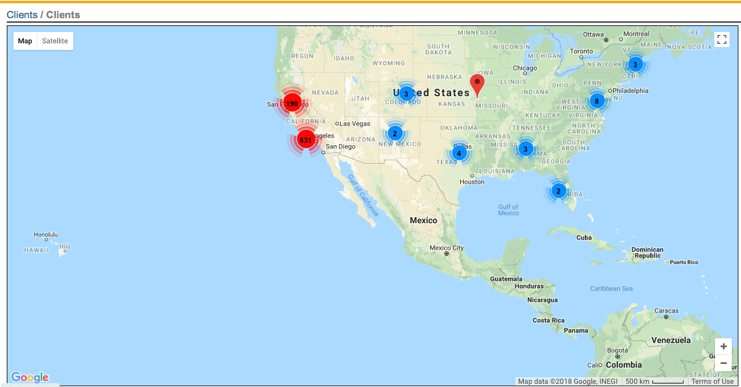
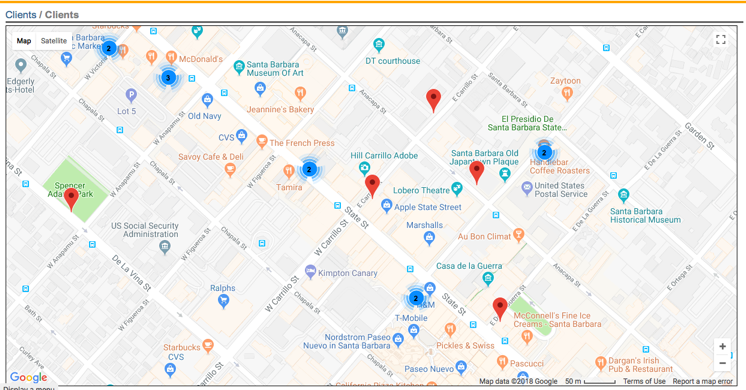
Mapping the data will result in a map that shows pin drops for the clients found in your filter results:
- A red pin drop indicates a single client location.
- A blue circle indicates more than one client but less than 10 clients in the same general location.
- A yellow circle indicates 10 or more clients within the same general location
- A red circle indicates 100 or more clients within the same location.
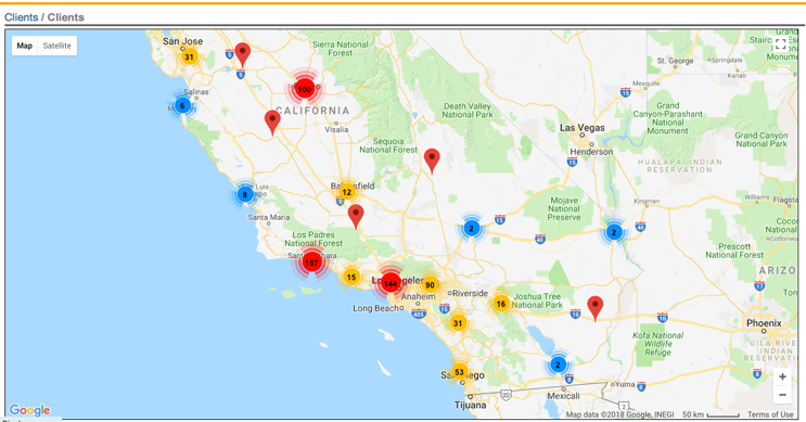
You can drill down by clicking on the blue, yellow or red circles to see the more detailed map for those clients represented by the circle:
You can continue to drill down, until all clients are mapped individually:
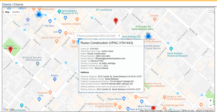
You can click on an individual red pin drop to get the name of the company represented by the pin drop. The name is a link back into your Neoserra database for that client record. Hovering over the name also gives some key details about the client:
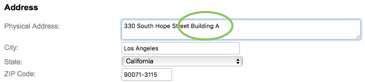
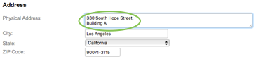
This feature is dependent upon accurate and complete address information in your database. Currently, the address information in your database is matched to the correct latitudinal and longitudinal coordinates using OpenStreetMaps. OpenStreetMaps will give an internal accuracy score letting Neoserra know whether the address is likely to be correct or not. If the accuracy score is too low, then Neoserra will make another attempt at mapping the address using Google Maps. Ultimately, addresses that include extraneous data, such as "Building X, Floor 99", or "Villa Tranquility" may not resolve to correct coordinates. A lot of times this additional address information can be safely added after a comma on a second line. For example, this is not a valid address:
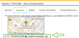
And Neoserra will tell you that the level of accuracy for this address is only at the city level - not the street level:
But this is a valid address, with a comma after the street address and the additional information on a second line:
If Neoserra is not able to obtain exact latitudinal and longitudinal coordinates then it will resolve to the city level, and you may see multiple businesses "clustered" in the the center of the city, on the map. However, you can also enter in your own latitudinal and longitudinal coordinates, if you know them. On the address tab of the client record, you will notice a "Locate" link:
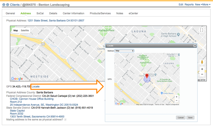
Using this interface, you can either:
- Manually move the red pin to the correct location for this client.
- Use the "Plus Codes" menu option to enter in the client's plus code which is an international coding system that are generated from latitude and longitude and thus already exist for every spot on the planet. Nobody needs to apply for them, register them, or pay for them. You can find more about plus codes here: https://plus.codes.
- Manually enter in the Latitude/Longitude information for the client.
Now that you are comfortable mapping your clients and managing their coordinates, next you might want to consider taking your client data and overlaying it on top of other maps using either Google Earth or ArcGIS. For example, you might want to take a FEMA disaster map, and overlay your client data to see which clients were (or were not) affected by the recent disaster. This is discussed in more detail in the FAQ titled: How do I overlay a Neoserra map on either Google Earth or ArcGIS.
Want more? Browse our extensive list of Neoserra FAQs.