How are the read-only fields (such as Opportunity Zone, Rural Area, CDFI, etc.) updated on the Address tab of the client record?
In this FAQ we will discuss the fields on the Client's Address tab that are automatically updated and maintained by Neoserra:
- GPS: Latitudinal and Longitudinal Data
- Rural Location
- Census Tract
- Opportunity Zones
- Persistent Poverty
- CDFI Area
- SSBCI Qualified
- Filtering using these read-only fields
The majority of these fields are dependent upon the client's physical location, the one exception being the SSBCI Qualified field. In the absence of accurate and complete address information, Neoserra cannot properly update these read-only fields.
GPS: Latitudinal and Longitudinal Data
Neoserra will attempt to determine the correct latitudinal and longitudinal coordinates of the physical address entered into the database, and show the coordinates within the GPS field. It should be noted, that in the absence of a complete or accurate physical address on the client record, none of the other fields presented on the Address tab of the client record can be accurately maintained.
Addresses that include extraneous data, such as "Building X, Floor 99", or "Villa Tranquility" may not resolve to correct coordinates. A lot of times this additional address information can be safely added after a comma on a second line. For example, this is not a valid address:
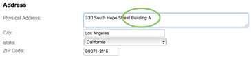
And Neoserra will tell you that the level of accuracy for this address is only at the city level - not the street level:
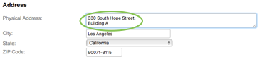
But this is a valid address, with a comma after the street address and the additional information on a second line:
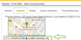
If Neoserra is not able to obtain exact latitudinal and longitudinal coordinates then it will resolve to the city level, and you may see multiple businesses "clustered" in the the center of the city, on the map, which, in turn, means that the census tract and correspondingly the Opportunity Zone, Rura, Persistent Poverty and also the HUBZone information are also not correct.
However, you can also enter in your own latitudinal and longitudinal coordinates, if you know them. On the address tab of the client record, you will notice a "Locate" link:
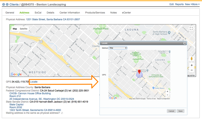
Using this interface, you can either:
- Manually move the red pin to the correct location for this client.
- Use the "Plus Codes" menu option to enter in the client's plus code which is an international coding system that are generated from latitude and longitude and thus already exist for every spot on the planet. Nobody needs to apply for them, register them, or pay for them. You can find more about plus codes here: https://plus.codes.
- Manually enter in the Latitude/Longitude information for the client.
If you use the "Locate" link and manually change the location of the client, then Neoserra will respect your edits and it will not overwrite the coordinates. However, if you then subsequently make a change to the address field, then Neoserra will again attempt to determine the location coordinates and potentially overwrite your manual edits.
Rural Location
From a land mass perspective, most of the United States is deemed to be a rural area. But different agencies use different methods for determining whether an address is rural, or not. In Neoserra you will find two different rural lookups. One is based upon the Census Bureau Rural definition and one is based upon the USDA RBS Rural definition. Both Rural Location fields are dependent upon accurate and complete address information:

USDA RBS Rural Tracking
The USDA RBS Rural definition is the rural classification that SBA has selected effective 10/15/24 to be included in the Nexus exports. This change was made during the Q4 FY2024 exports and is based on the following definition:
- An area is considered rural if the area has 50,000 or fewer inhabitants and is not adjacent to a city with a population of more than 50,000;
- Consistent to USDA's Rural Development definition for Rural Economic Development Program
If a client is located in a USDA RBS Rural area, then this could qualify them as being part of an underserved community.
Census Bureau Rural Tracking
The Census Bureau's urban-rural classification is a delineation of geographic areas, identifying both individual urban areas and the rural area of the nation. Neoserra will use the Urban Area Census (UACE) information to automatically determine whether a client is located in a Rural area based upon the Census Bureau Rural Information
The Census Bureau defines rural as any population, housing, or territory NOT in an urban area. The Census Bureau's rural definition is closely tied to the urban definition. It is important to realize that rurality under the Census Bureau's method of tracking is not based upon a zip code or county designation, it is based upon blocks determined by the Census Bureau.
Census Tract
Similar to the Rural Zone information, the Census Tract is updated based upon the GPS coordinates of the client's address. The Census Tract is then used to determine whether the client is located in an Opportunity Zone, is located in an area of Persistent Poverty, or is located in a CDFI area.
Census tracts are small, relatively permanent statistical subdivisions of a county. They are uniquely numbered in each county with a numeric code. Each census tracts includes on average about 4,000 inhabitants, with the minimum Population no less than 1,200 and the maximum Population no more than 8,000 inhabitants. Census tracts are designed to be relatively permanent over time so that changes within a geographic area can be compared from decade to decade.
A change may occur when the population in a tract exceeds 8,000 people, in which case a tract is split into 2 or more tracts and are given an extension to their existing numeric code. Census tracts with less than 1,200 people are merged with a neighboring tract and are given a new numeric code.
The Neoserra Census Tracts are based upon the 2020 survey.
Opportunity Zones
Per the IRS website: "Qualified Opportunity Zones were created by the 2017 Tax Cuts and Jobs Act. These zones are designed to spur economic development and job creation in distressed communities throughout the country and U.S. possessions by providing tax benefits to investors who invest eligible capital into these communities. The first set of opportunity zones, covering parts of 18 states, were designated on April 9, 2018. opportunity zones have now been designated covering parts of all 50 states, the District of Columbia and five U.S. territories." Opportunity Zones are based upon census tracts and you can find a list of all designated Opportunity Zones here.
The Opportunity Zone checkbox is a read-only checkbox that can be found on the Address tab of the client record. It is automatically updated based upon the census tract corresponding to the physical address of the client.
Persistent Poverty
The Persistent Poverty information has been added to Neoserra in August 2023. Similar to the Opportunity Zone and Rural Status fields, the Persistent Poverty field is a read-only field on the Address tab of the client record, and it too is dependent upon accurate address information since the information is derived from the client's census tract data.
The data is retrieved from the Census Bureau.
If a client is located in an area of Persistent Poverty, then this could qualify them as being part of an underserved community.
CDFI Area
The U.S. Department of the Treasury?s Community Development Financial Institutions Fund (CDFI Fund) helps promote access to capital and local economic growth in urban and rural low-income communities across the nation through monetary awards and the allocation of tax credits. CDFI Areas are also based upon the Census Tract of the client, and thus is dependent upon accurate and complete address information for the client. A CDFI Investment Area is a geographic area in the United States that meets at least one of the following criteria:
- Has a population poverty rate of at least 20 percent
- Has an unemployment rate 1.5 times the national average
- For a metropolitan area has a median family income (MFI) at or below 80 percent of the greater of either the metropolitan or national metropolitan MFI
- For a non-metropolitan area that has an MFI at or below 80 percent of the greater of either the statewide or national non-metropolitan MFI
- Is wholly located within an Empowerment Zone or Enterprise Community
- Has a county population loss greater than or equal to 10 percent between the two most recent census periods for Metro areas or five percent over last five years for non-Metro areas
Neoserra uses the CDFI Program Updated Investment Area Eligibility 2016-2020 ACS Data as published on the https://www.cdfifund.gov/mapping-system website.
SSBCI Qualified
This read-only field is also located on the Address tab of the client record in Neoserra, however, this field is not specifically based upon the physical address of the client. A SSBCI Qualified client is any client who meets any one of the following criteria:
- Any client with less than 10 employees
- Any client located in a CDFI Area
- Any client located in an Underserved Community
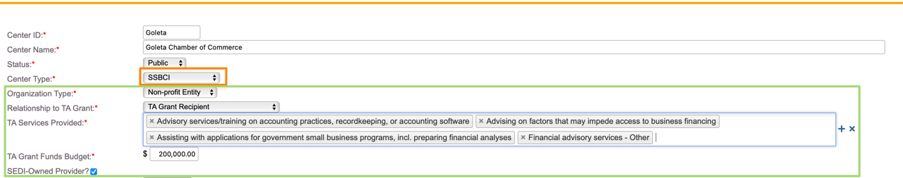
This field is only displayed if you have a center in your database with a SSBCI Center Type:
Filtering using these read-only fields
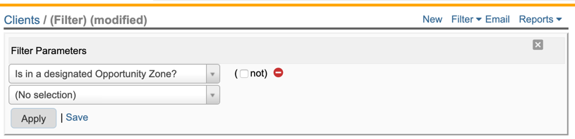
Neoserra has also been enhanced with a filter for each of these read-only fields. For example, you can find all clients located in an "Opportunity Zone?" as follows:
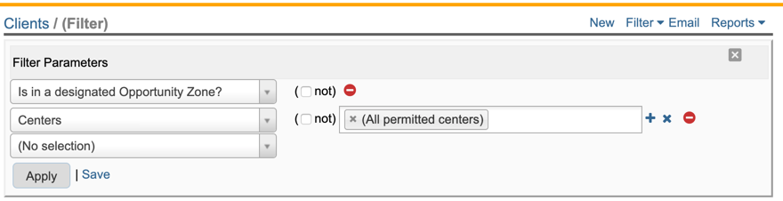
If you want to apply this filter to your scorecard to see network wide impact with Opportunity Zone clients, then it is important to add a center selection to the filter:
You can save the filter and then apply it to your scorecard as shown below:

The scorecard results will be be filtered to show only those clients who are located in an Opportunity Zone.
Want more? Browse our extensive list of Neoserra FAQs.